Desk Report
Oniket Desk
The simultaneous breach of danger levels across four major rivers in northeastern Bangladesh coupled with 72-hour flood warnings for Sunamganj, Habiganj, and Sylhet is not an isolated meteorological event. It is the latest expression of a deepening structural vulnerability in one of Bangladesh’s most ecologically sensitive and agriculturally critical regions, and it demands a policy response calibrated to medium-term climate realities rather than the seasonal emergency management cycle that has historically defined the state’s engagement with flood risk.
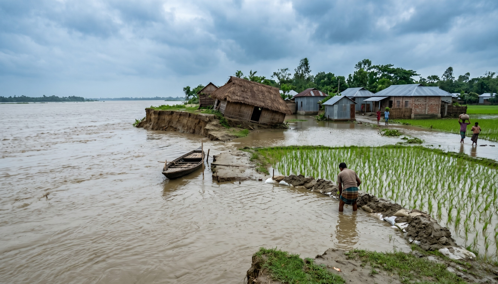
The districts now under flood threat Netrokona, Moulvibazar, Sunamganj, Habiganj, and Sylhet sit at the heart of Bangladesh’s haor basin, a vast network of wetland depressions that collects runoff from the Meghalaya plateau and upstream river systems originating in India’s northeast. The Bhogai-Kangsha river flowing 82 centimetres above its danger level at Jariajanjail, the Manu River 72 centimetres above danger at Moulvibazar, and the sharp 1–1.5 metre rise in the Surma and Kushiyara rivers collectively indicate that this is a basin-wide event, not a localised overflow. Rainfall of 160 millimetres recorded in Kishoreganj and near-equivalent volumes across nine other districts within 24-hour period signal precipitation intensities that are becoming characteristic of pre-monsoon convective events linked to warming Bay of Bengal sea surface temperatures and altered moisture flux patterns.
The critical vulnerability in the haor region is agriculture. The Boro rice crop, the dominant paddy variety in this ecology, is typically harvested between April and May, precisely the window in which pre-monsoon floods strike. A sustained flood event in this period does not merely damage standing crops; it can eliminate the entire season’s harvest across hundreds of thousands of hectares, with cascading consequences for food security, rural income, and agricultural credit repayment. The FFWC’s 72-hour warning, while operationally valuable, reaches communities after crops are already in the ground and harvesting equipment is not yet fully mobilised, a timing gap that medium-term policy must structurally address.
Bangladesh has invested considerably in flood forecasting infrastructure, and the FFWC’s capacity to issue district-level warnings with a 72-hour lead time represents genuine institutional progress. However, the conversion of forecast information into protective action at the community level remains inconsistent. Farmers in remote haor villages, fisherfolk on riverine chars, and households in low-lying mouzas require localised, actionable warnings, not district-level advisories that may not descend through administrative channels in time to enable meaningful response. The current warning dissemination architecture retains a significant last-mile gap that technology, properly deployed through mobile networks and community radio, could substantially close.
The most consequential medium-term intervention is the development of a hydro-specific climate adaptation strategy that integrates agricultural calendars, flood forecasting, and infrastructure investment within a single planning framework. The timing of Boro rice cultivation in the haor ecosystem needs to be progressively recalibrated through the promotion of shorter-duration, early maturing varieties that can be harvested before peak flash flood risk materialises. Agricultural extension services in haor districts should be retooled to support this transition, with seed systems, procurement arrangements, and credit products aligned to the revised cultivation calendar. This is not a novel proposal, research institutions have developed viable shorter-duration varieties, but adoption at scale requires a sustained public investment commitment that has not yet materialised.
River dredging and embankment management in the haor belt warrants renewed prioritisation. Decades of sedimentation have progressively reduced the flood-carrying capacity of haor-feeding rivers, lowered effective danger thresholds and increased the frequency with which marginal rainfall events produce dangerous overflows. A systematic, evidence-based dredging programme designed around hydraulic modelling rather than political constituency, would meaningfully expand the buffer between normal high-water and danger levels. This is a medium-term infrastructure commitment with long-term returns.
Trans-boundary water management with India requires greater diplomatic and technical urgency. A significant proportion of the water loading in haor-basin rivers originates from catchments in Meghalaya, Assam, and Tripura. Bilateral data-sharing arrangements for real-time upstream rainfall and reservoir release information would extend Bangladesh’s effective flood forecast window and improve warning accuracy. The existing Joint Rivers Commission framework provides the institutional mechanism; what is needed is the political will to operationalise it at a technical level.
Finally, a parametric disaster risk financing mechanism, structured around rainfall and river level indices would allow rapid resource disbursement to affected communities without the delays inherent in post-event damage assessment. Bangladesh’s repeated flood exposure makes it a natural candidate for such instruments, and multilateral climate finance mechanisms increasingly offer concessional terms for climate-vulnerable least developed countries seeking to build pre-positioned response capacity. The case for accessing these instruments is now compelling.